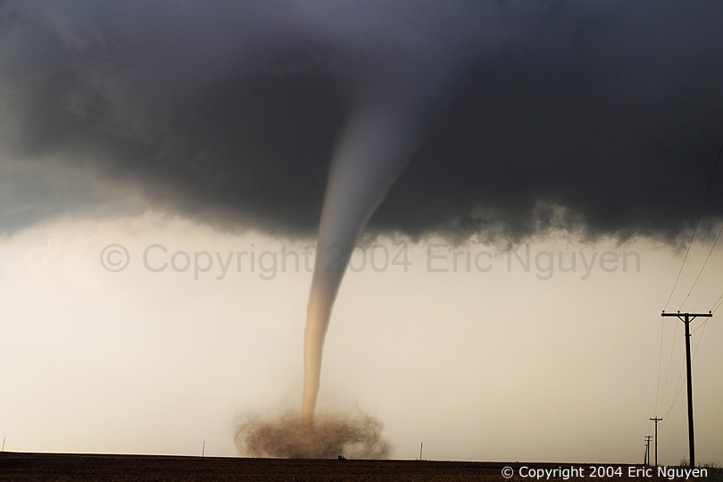
A tornado is best described as a powerful, rotating column of air that reaches from the base of a thunderstorm cloud to
the ground.
Thunderstorms form in hot damp air that is approaching a cold front. Some thunderstorms produce strong winds, particularly ones which change direction with height. These are called wind
shears.
Horizontal winds that are moving in different directions at different altitudes can form horizontal columns
of rotating air. This rotating air gets lifted into the thunderstorm by strong updrafts; as it rises, it stretches and tightens,
causing it to spin even faster (like a figure skater who draws in her arms to rotate more quickly).
Diagram by Bill Willis
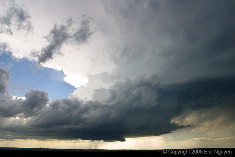
The diagram at the left shows a supercell thunderstorm that has
generated a tornado. Note the classic thunderstorm shape, and especially the mammatus clouds (shown also in photo below) that
are characteristic of tornado-producing storms. Witnesses often describe these clouds as being greenish-blue.
A large mass of rotating air is called a mesocyclone, or
supercell thunderstorm, and can easily spawn tornadoes. Supercell thunderstorms have strong rotating updrafts with large vertical
wind shears. Wind speeds in tornadoes themselves can reach 480 km/h, although only one in every fifty tornadoes have winds
greater than about 320 km/h. The large hail that often precedes a tornado forms in the intense updrafts that feed the thunderstorm.
While tornadoes can occur all over the world, they are most frequent in the United States, where some 1,000 tornadoes
per year touch down, killing 60 people and causing around $850 million in damage nationwide.
Tornado Intensity
The intensity of tornadoes is measured by the Fujita
Scale. The scale is divided into levels ranging from F0 to F6, with F6 being the strongest (and rarest) tornado.
The Fujita Scale
F-Scale Number
Intensity
Wind Speed
Type of Damage Done
F0
Gale tornado
65-112 km/h
Some damage to chimneys; breaks branches off trees; pushes over shallow-rooted trees; damages signs.
F1
Moderate tornado
113-180 km/h
Peels shingles off roofs; mobile homes pushed off foundations or overturned; moving autos pushed off roads;
attached garages destroyed.
F2
Significant tornado
181-252 km/h
Considerable damage: roofs torn off houses; mobile homes demolished; boxcars pushed over; large trees snapped
or uprooted; light object missiles generated.
F3
Severe tornado
253-332 km/h
Roof and some walls torn off well constructed houses; trains overturned; most trees in forests uprooted
F4
Devastating tornado
333-418 km/h
Well-constructed houses leveled; structures with weak foundations blown off some distance; cars thrown and
large missiles generated.
F5
Incredible tornado
419-512 km/h
Strong frame houses lifted off foundations and carried considerable distances to disintegrate; automobile sized
missiles fly through the air in excess of 100 meters; trees debarked; steel re-enforced concrete structures badly damaged.
F6
Inconceivable tornado
512-610 km/h
Very rare. Damage these tornadoes might produce would probably not be recognizable along with the mess produced
by F4 and F5 winds that would surround the F6 wind.
Note that the Fujita scale measures
intensity - the strength of a tornado's winds, not the size of the funnel cloud. Large tornadoes can be weak, while small
tornadoes can be strong.
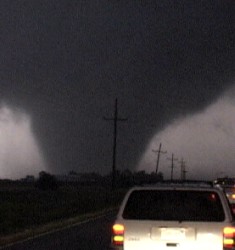
In 1987, an F3-F4 tornado touched down in Edmonton, Alberta, spending over an hour on the ground and causing
27 deaths and $250 million in damages as it worked its way for 40 kilometres across the edge of the city at 35 km/h.
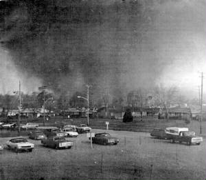
The tornado approaching Edmonton (left) and what was left of the Evergreen trailer park afterward.
First of all how a tornado forms:
First of all it's a really hot day right.
It's about 38 degrees,
And the warm moist air is pushing off the ground into
the clouds, meeting cold dry air.
The two keep on meeting eachother on and on
through out the day,
creating cloud formation,
and by evening, a storm is developed.
A cap cloud ( on top of the thunderhead)
brakes and the winds have such strength,
that it flattens out the top of the cloud, giving it a classic anvil shape, mean while the winds
start to spiral,
creating a wall cloud,or-mesocyclone.
Then micro-bursts and down drafts cause the inside of the cloud to spiral.
Then comes the tornado it's self.
A large thunderstorm or severe thunderstorm,
is called a supercell.
THE FUJITA TORNADO DAMAGE WIND SCALE
The fujita Tornado damage wind scale goes from:F0, F1, F2, F3, F4, and F5.
F0 TORNADO-Wind estimate***<73(mph)-Light
damage. Some damage to chimneys;
Branches broken off trees;
shallow-rooted trees pushed over; sign boards damaged.
THE F1 TORNADO- Wind speed- 73-112 (mph)-moderate damage. Peels surface
off roofs; mobile
homes pushed off foundations or overturned;
moving autos blown off roads.
THE F2 TORNADO-wind speeds<113-157(mph). Considerable Damage.
Roofs torn off homes demolished;
boxcars overturned; large
trees snapped or uprooted;
light-object missiles
generated; cars lifted off
ground.
THE F3 TORNADO-Wind speed<158-206(MPH). Severe Damage.
Roofs and some walls torn off wellconstructed houses; trains
overturned; most trees in forest uprooted, heavy cars lifted
some distance; cars thrown and large missiles generated.
THE F5 TORNADO-THE BIGGEST-wind speed<261-218(mph).
Incredible Damage.Strong frame houses leveled off
foundations and swept away; automobile-sized missiles fly
through the air in excess of 100 meters*(109yds); trees debarked; incredible phenomena will occur.
TORNADOES
Tornadoes are not always the most sought after phenomena in storm observing,
however, when they are occurring, you can't help but go after them. Often times I'm extremely fascinated by their structure
and how quickly they evolve into very different looking tornadoes. I like variety, so tornadoes are one of the interesting
things I like to see while storm observing. I usually try to get the structure along with the tornado, however, I'll
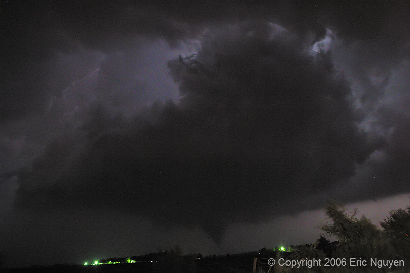
sometimes get close to get some debris cloud shots. I don't particularly like chasing these things at night. So
when it gets dark I usually break off the storm, unless its behaving and is allowing a safe viewing of the updraft.
This is a collection of tornadoes that I have found to be the most fascinating and beautiful of all of the tornadoes I've
seen in my 10 years of storm observing.
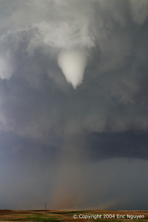
This is a beautiful long-lived tornado that I observed near Attica, Kansas on May 29, 2004.
Notice the bottom half of the tornado is lit by the sun! This storm was struggling for quite some time until it hit
the deeper moisture, after that it was a prolific tornado producer. This tornado moved north and then northwest, as
the updraft began to stretch into a thin column. At times the tornado would have a large debris cloud, with the bottom
half of the tornado doing some interesting movements.
A gorgeous LP to classic supercell produces a tornado near Wanblee, South Dakota. Grapefruit
sized hail fell around the tornado which was observed by chasers very close to the tornado. Image is looking due west
on June 7, 2005.
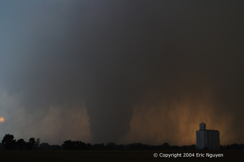
This is a large tornado near Argonia, Kansas on May 29, 2004. The first image is looking southeast
as we raced east to flank it. We lucked out and made it just in time to Argonia before the tornado hit. It became
a large stove pipe as it wrapped in rain backlit by the sun. Later on it became a large barrel shaped tornado before
growing into a large wedge again. We left this tornado to pursuit another developing tornado a half mile to our east.
An amazing display of the life cycle of a tornado that occurred on June 9, 2005 at Hill City, Kansas.
What began as a classic cone tornado developed into a strong wedge tornado 2 miles south of Hill City, Kansas. The white
car you see in the foreground is Scott Blair whom I was chasing with that day. Once that last image was taken, we blasted
north into Hill City as the tornado curved north heading for town.
Looking southeast at a tornado near the town of Patricia, Texas, on May 5, 2006. This evolved
into a long thin rope as it drifted northward.
The first image is a weak tornado near Gunter, Texas. One hour later a second and third tornado
developed near the town of Anna, Texas. The two other images are of the third tornado which moved into the town of Westminster,
Texas. This tornado struck at 10:30pm, killing 3 people. Despite a tornado warning issued for this storm, no siren
system existed to warn this town. Two elderly people were killed while they slept, a third was a young man that took
shelter under a staircase.
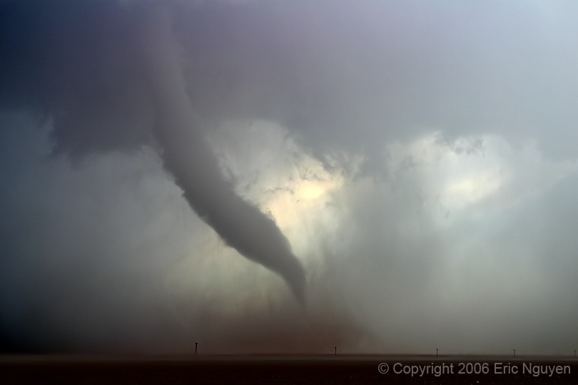
This was a violent tornado that developed north of Argonia, KS on May 29, 2004. This tornado
moved northward as it morphed into a wedge just as it was wrapping in rain. The video from this tornado shows amazing
motion, showing it to be a strong to violent tornado.
On June 12, 2005, a long-lived tornadic supercell developed northwest of Jayton, Texas. These
are images of three different tornadoes that occurred on this day spanning two hours. Luckily these tornadoes occurred
in rural areas. The first tornado developed very close to the town of Spur, Texas, lasting several minutes. The
second and third images is of a strong tornado that occurred much later, near the town of Girard, Texas. Lastly, the
6th tornado we observed that day, was one that occurred northwest of Jayton.
This friendly tornado developed near Julesburg, Colorado moving into the Nebraska Panhandle as it
crossed Interstate 80. Traffic continues without hesitation until after the tornado was north of the highway.
Luckily no cars were damaged as this tornado moved northeast on June 10, 2004. It later became a spectacular stove pipe
shaped tornado.
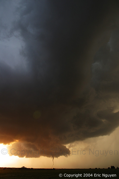
A photogenic tornado looking east near the town of Hill City, Kansas on April 10, 2005. This
was a cold core setup where storms were firing along a sfc trough ahead of a stacked low. Hail was falling at the time
which shows up as white streaks in the image. We observed a total of 5 tornadoes that day.
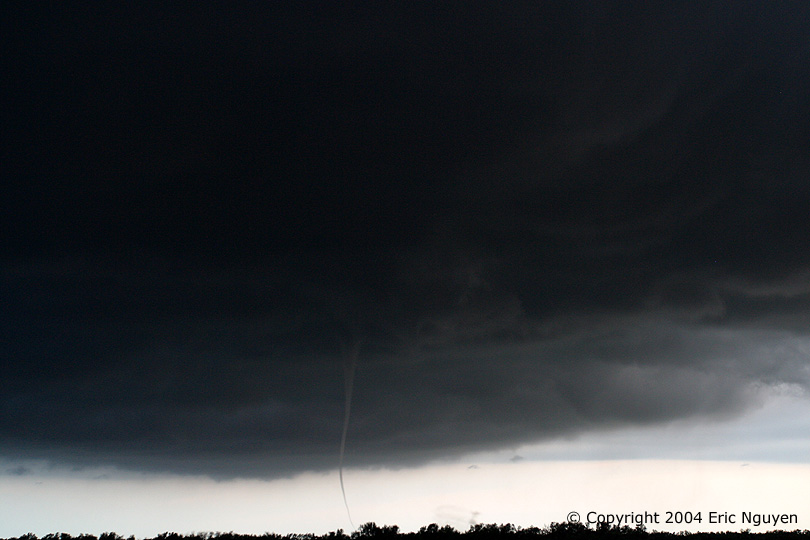
This was an interesting tornado that also occurred on April 10, 2005. It was the second tornado
of five that we observed that day. The view is looking west-northwest as a weak tornado travels over the Cedar Bluff
Reservoir in Kansas. We wouldn't have know it was on the ground if we didn't see the debris cloud crossing over the
water.
24 hours later from the tornado image you see above, a large tornado crossing
I-35 in OKC a few miles north of the previous days tornado track. View is looking WNW as we brace for the RFD which
has wrapped around us as we are in the bears cage. This tornado was rated F3 and luckily this one didn't kill anyone
either. These images are video captures since it wasn't safe enough to tripod the stills.
A very neat looking tornado north of Interstate 80 in the Nebraska Panhandle on June 10, 2004.
This storm seemed to really get its act together just as it was beginning to produce this tornado. Later on it had full
condensation to the ground and was quite strong.
This is the stove pipe tornado near Big Spring, Nebraska on June 10, 2004. We were just south
of it looking northwest and north as it moved east. We quickly moved our van up the road a few yards to get away from
the power lines in case the lines went down from the strong RFD winds. We had gusts measured at over 80 mph, so at times
it was difficult to take stills.
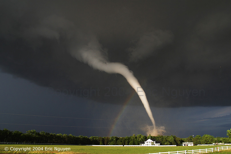
This is one of the most beautiful tornadoes I have ever seen, located near Mulvane, Kansas on June
12, 2004. We were on the west side of this tornado with a gorgeous white tornado with a rainbow. The left image
has some action to it, as you can see the streaks of hail moving inward towards the tornado. The right image is just
as the tornado crossed the road with debris falling from the sky.
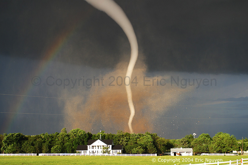
An amazing view of the Mulvane, KS tornado with small tubes embedded in the top region of the tornado.
This tornado damaged a business and a home, which received an F3 rating. Luckily the occupants inside were in a basement.
Another shot of the Mulvane, KS tornado as it began to rope out. Even 10 minutes after the
tornado dissipated, we still had small pieces of light weight debris falling from the sky.
This is a small tornado touching down near Rock, KS on June 12, 2004. This time we flanked
the storm to get it backlit by the sun as well as getting some structure in the shot. I usually try to get diverse images
and this was my opportunity that day to do so. A beautiful and friendly looking tornado!
Can you see it? its difficult to see tornadoes such as this unless your looking for it.
This is a thin rope tornado moving southeast from Rock, KS on June 12, 2004. It was small enough that it didn't hit
anything except for trees and power lines. This tornado actually remained thin and lasted for several minutes.
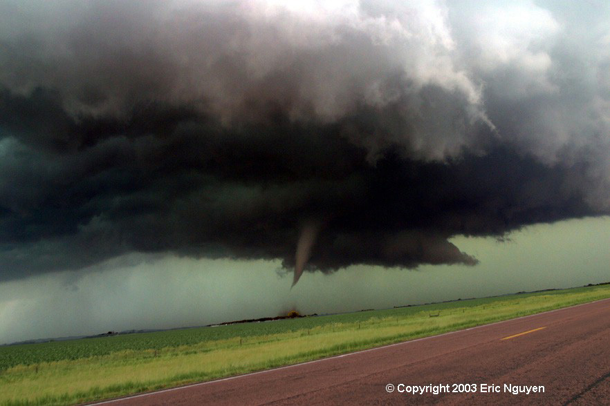
This is a tornado near Atkins, Nebraska on June 9, 2003. This started
out as a horizontal funnel which slowly turned towards the ground and developed a debris cloud. This was the first tornado
of the day for us. Afterward, a second and much larger tornado developed to our south and moved east into O'Neil, Nebraska.
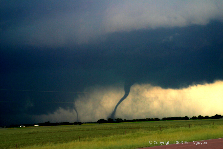
These are a few tornadoes from an outbreak of tornadic supercells that occurred over SE and
E South Dakota on May 24, 2003. This was our last chase of the season, so we hoped it would count! We witnessed
eleven tornadoes of all shapes, sizes, and colors. Our storm originally formed in far northeastern Nebraska and moved
north with often times a westward motion as it backbuilt along a northward moving boundary. We ended the day in Sioux
Falls, South Dakota as our storm hit the northern parts of the city.